Tuesday, October 20, 2015

A Little Fall Color and Carnage From Wyoming

This is a follow up to a post from earlier this year about the Big Sandy Opening area of the Wind River range in southwestern Wyoming. I made it back in late September for a short visit with my son who is working there for the Forest Service this summer and fall. Unfortunately, due to schedules and continuing issues with my knee, we were not able to hike in to see the Cirque of the Towers - the goal for the summer. We will try again next year if he is working out there again.

The weather was warm and dry which was a nice change from the first trip. We spent most of our time checking the Forest Service back roads around the Big Sandy Opening area as hunting season was just getting started. We met some very interesting people and saw some unusual things but I did not take many pictures for a variety of reasons. Below though, are a few that hopefully represent the beauty of the area and the wildness that is still there.

Fall colors on the way to the cabin.


Temple Peak from Muddy Ridge.


We traveled one day over to see Square Top mountain. Lower Green River Lake is in the foreground. I would like to hike up into the valleys below Square Top some day.


Fall colors from the Irish Canyon area.


Now for the carnage. Irish Canyon is used for cattle and sheep grazing earlier in the year. While traveling through it, we came across the remains of a lamb. We could not determine what took it out but, according to a local rancher acquaintance, there are wolves, mountain lions, bears and coyotes in the area. It was amazing to see the skin and fur just peeled away and the vertebrae and rib cage nearly intact. We looked for the head but never found it. I am sure that finding remains like this is not uncommon for some people but it was definitely something new for us.


Some color from the front yard of the cabin.


And finally a view up the Big Sandy river toward the southern end of the Winds.


It was an excellent but too short trip. The dispersed camping in the Big Sandy Opening is really good, especially in the upper valley. We will be going back to explore more of the Winds whether the kid is working there or not.

Thanks for reading!

Tuesday, August 11, 2015

The Big Sandy Opening, Wyoming

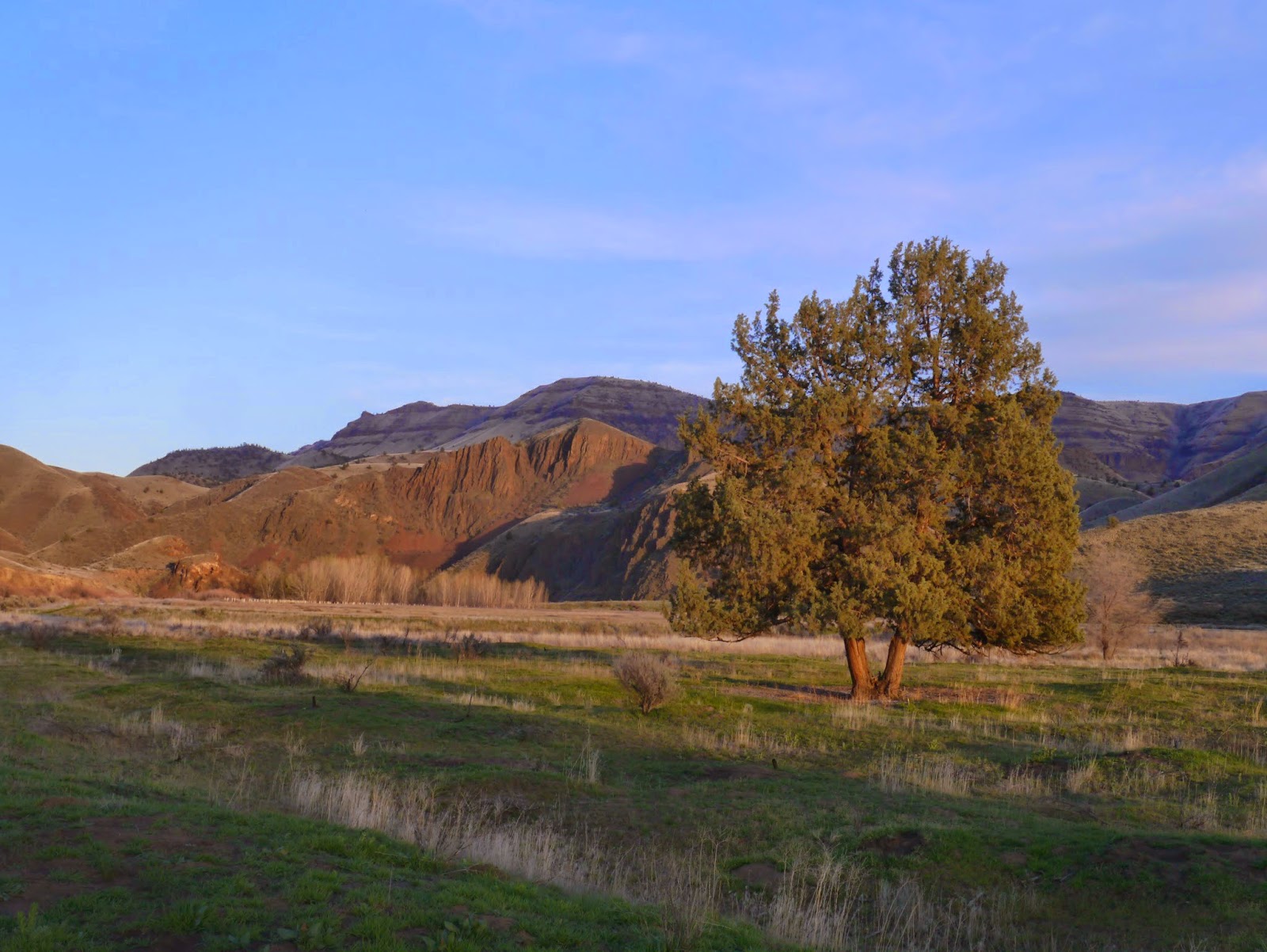
The Big Sandy Opening is a river drainage in west central Wyoming that provides very easy access to the southern end of the Wind River mountain range and the Bridger Wilderness. The Opening is at the top of a sometimes very rough dirt road that is typically accessed from Wyoming Highway 191 at a junction in Boulder, about 12 miles south of Pinedale. It is about 45 miles on mostly dirt road to get to the upper meadow.

A view up the Big Sandy meadow toward the Wind River Range.

For those who are familiar with the Winds, there is no need to describe their beauty and uniqueness. For those not familiar with them, this is one of, if not the most, beautiful mountain ranges in our country. It may be the wildest because it is less used and managed/regulated than the ranges in the  National Parks. It seems though that a strong case could be made for it to be one.The range is part of the Continental Divide, is about 80 miles long and runs north-south through west central Wyoming. There are miles after miles of glacially polished granite walls, towers and spires whose grandeur is difficult to capture in words. It is very similar in some ways to Yosemite but the amazing valleys that intersperse the range are unique, at least to me, to Wyoming and Montana. If you love mountains, the Wind River Range should be on your bucket list of destinations if you have not been there.

Our reason for going was two-fold. 1) We had been to most of the mountain ranges in the West but not the Winds. 2) Our son Kyle is working for the US Forest Service this summer/fall and is stationed at a Forest Service Guard Station that is located on the road going up to the Big Sandy Opening. It seemed like a good time for a visit.

The plan was for me to fly out ahead of Joanie and work with Kyle as a Forest Service Volunteer for 10 days. The following week she would drive the pop-up camper from Oregon with Taz and we all would go for a backpacking trip into the Winds for a few days and then drive home together.

I flew into the airport at Jackson where Kyle picked me up. We had a wonderful dinner at a restaurant called Local because most of the menu items were raised locally. It had been about 6 years since our last trip to the Tetons - it was surprising how much Jackson has grown. Still a wonderful town though.

The next day Kyle and I provisioned a week's worth of food in Jackson and headed for Pinedale, about 90 miles to the south. After a very nice lunch at the Wind River Brewing Company and a visit to The Great Outdoor Shop for a Wyoming fishing license for me, we were off to Kyle's outpost. Along the way there are several very interesting Historical Markers. I did not know that the Mountain Men, John Fremont, Kit Carson and early Oregon Trail travelers passed through this area. 

A view towards Kyle's station.

The cabin sits at 8250 feet elevation. There is propane for lights, cooking and heat..There is a generator for charging devices but no TV, cell service or Internet. The cabin is old and rustic but is very livable. It would be a great place to take a break from being wired and online all the time.

The TV and Internet were replaced by cloud shows almost every day.

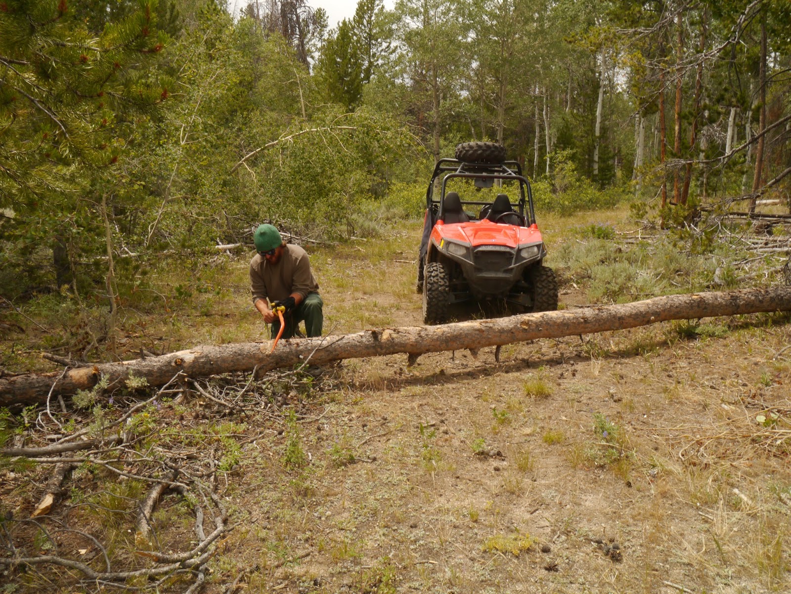
The days passed by quickly. Kyle's primary duties are maintaining the facilities at the Big Sandy trail head, working with campers in the dispersed sites and driving the many forest roads in a utility vehicle. The trail head is very popular because it provides the easiest access to the Cirque of the Towers, one of the most frequently visited areas of the Winds. The parking lot has license plates and climbers from across the country.  The purpose of traveling the forest roads is to make sure there are no downed trees across the roads or other issues that need to be resolved prior to hunting season which is the busiest time in this area.

The Big Sandy trail head and parking lot.


Kyle clearing a downed tree.

The evenings were ours though and were focused on learning our new sport - fly fishing. We both had geared up earlier in the summer and collected a ton of reading material so it was now time to get serious about it.

Kyles fishing the Big Sandy river. It is hard to imagine a prettier place to cast your first flies.


Due to multiple health issues for me, we went on a day hike to measure my capabilities for the backpack trip and learned a valuable lesson about weather in the Winds - it can change quickly and drastically. It was only about 30 minutes from the time the picture below was taken to when we were sitting under some trees waiting out a huge storm with lightning, thunder, pea sized hail and a torrent of rain. Based on a forecast for better weather, we had not taken all of our rain gear so parts of both of us got soaked. The trip was a success though in that we determined I could make it to Big Sandy Lake, a six mile hike.

We decided though that it would be a good idea to hire wranglers to  horse pack our heavy gear up to the lake and then we would walk everything out. We worked out a plan with Wes from the Big Sandy Lodge. The Big Sandy Lodge is also at the end of the dirt road, not far from the trail head. It is an incredibly beautiful and peaceful place. If you are looking for a place to really disconnect and relax, this lodge is definitely worth considering.

The view from the fire pit at Big Sandy Lodge. Yes, that is a beaver lodge at the far side of the lake. It houses multiple beavers that have a dam at the bottom of the lake. It is really cool to watch them work the dam and swim around the lake in the evening.

Joanie and Taz would arrive on Saturday. The plan for the back pack trip was to hike in on Monday and set up a base camp at Big Sandy Lake for 3 nights. Sheryl and John from the lodge would pack the gear to the lake and leave indicators to the site where they dropped it. They found a very nice site at the far end of the lake. We were fortunate to dodge some nasty weather from a cold front that was passing through. We had one brief snow shower but after it passed, it was just cloudy, windy and cold. The weather though, did provide some good photo opportunities from our campsite.


Tuesday was a rest day as neither Joanie, Taz or I had back packed for several years due to my health. A wilderness ranger friend of Kyle's pointed us to a very nice beach on the lake where we spent the afternoon reading and practicing our fly casting.

Joanie, Kyle and Taz with War Bonnet Peak in the background.

The goal of the trip was to get me to the top of Jackass Pass (and hopefully further) to get at least a partial view of the Cirque of the Towers. On Wednesday Kyle and I decided to go. Joanie stayed at camp with Taz as both were still feeling the effects of the hike in and the altitude. I gave it my best shot but we only made it to North Lake, well over a mile of tough hiking away from the pass. It was difficult to turn around but faced with the hike out the next day, it was the right decision. We were rewarded with great views of War Bonnet peak and other peaks as we walked back down. We chatted with two different groups that were hiking the Continental Divide Trail. They both had started in New Mexico during the third week of April and had some interesting stories.

War Bonnet Peak. The trail to the pass follows the trees up from the lake and then up to the right.
Haystack Mountain and East Temple Peak.
Looking down at Big Sandy Lake. Our campsite was at the top of the lake above the right side of the meadow.


Since we turned around early, we had an early dinner and then went fishing at dusk. None of us had ever seen so many fish jumping. It seemed that at least 5-10 were jumping at any given  moment. Kyle caught 3 and Joanie 1 on her 3rd cast ever. Unfortunately I neglected to bring a camera. 

The hike out on Thursday was tougher than the hike in because we were all carrying more weight, especially Kyle. We were all happy to arrive at the trail head parking lot.


We rested and organized our gear on Friday and reluctantly headed back to Oregon on Saturday.

This will be a memorable trip for our family and we are all glad that we were able to make it happen.  I plan to go back in the fall to see the aspen groves turn color, have another go at Jackass Pass and spend more time casting flies with Kyle (we are both hooked on fly-fishing now).

The Wind River Range is a very special area. As said earlier, if you love mountains, try to see them some day - you will not regret it. 

Safe travels and thanks for reading.


Tuesday, March 31, 2015

The Painted Hills, Oregon

The Painted Hills in Central Oregon had been high on our list of intended destinations for a long time. The Painted Hills are within one unit of the John Day Fossil Beds National Monument - the others are the Sheep Rock and Clarno units. We finally decided to go once daylight savings time started and schedules permitted. It would be a 3 day weekend trip with a focus on the Painted Hills unit - we would figure out the other units once we got there.

The drive was about 4 hours not including lunch in Prineville. We did not stop at the BLM or Forest Service offices (they are next door to each other) because I had spoken to both during the previous week. The people I spoke with in both offices were really pleasant and provided some great information.

It was immediately apparent that the drive was well worth the time. There are awesome pictures of this area but, like the Grand Canyon and similar places, it is hard to really capture the size and staggering beauty of them when taking your own photos. Below are a few attempts from the first overlook.


We then went to an area called the Painted Cove where you can get much closer to the formations. Their texture and color is amazing.


We knew we would be coming back the next day so opted to go find a spot for the night. The ladies at the BLM office had given me directions to a dispersed area about 10 miles away. It was a beautiful drive and it ended in a really nice area by the John Day river. It took awhile to find a spot as there were a lot of people there - we had forgotten that this was a spring break weekend. We finally found a little used spot due to difficult access that had great views in every direction..


Joanie and Taz enjoyed the late afternoon sun.


Taz went exploring and brought home her dinner (or so she thought). We looked around but found no other remnants of this deer which we thought was a little strange.


Unfortunately, the afternoon ended too quickly. Those puffy white clouds in the earlier pictures rapidly turned serious and it started raining about 6pm. We retreated to the camper and spent the evening watching and listening to waves of lightning, thunder and rain. Around 1am, we thought the worst had passed. Wrong - a really serious wind started howling about 1:30am. We could hear the gusts coming down the valley and when they hit, the truck and camper would shake - hard. It was the first big wind we had been in with the Fleet so had no idea what it could handle. My guess is that these gusts were around 30 mph and may have been higher. After the first few blasts we knew the Fleet would be okay if the gusts did not get stronger. Finally, after another wave of rain, it was over at about 3am. We woke to clear skies and no damage to the camper.


After a leisurely breakfast (it had been a long night), we went back to the Painted Hills unit. We went further up the overlook. The light and clouds had changed so it was a new perspective.


The view looking out from the other side of the ridge.


The rest of the day was a Voyage of Exploration. As mentioned earlier, this was a spring break weekend so there were a lot of people in the area. We decided we should head for the Sheep Rock unit and the Paleontology Center but wanted to find a camp spot first (because there were so many people around). We visited all the campgrounds within about a 30 mile radius and they were either too cold because of their altitude (40 degrees at 4300 ft with dense forest), not open yet for the season or depressing. We had a grand tour of the area and learned much about it. Joanie even commented, 'Wow, we really are Wandering the West'. After a very late lunch we decided to just head back to where we were the previous night and come back another time to visit the other units. We found a back road way to get there so that is what we did.

The spot from the previous night was still open so we moved in. We had new neighbors so put up the privacy tent we bought for the Cleanwaste system we use instead of a port-a-potty. Since this was its maiden voyage, we spent some time considering names like 'The Lunar Waste Disposal Module' or 'Der Poopenhausen' but, in the end settled on simply 'The Room with a View'.


The sunset had great potential but ended up being pretty but not sensational.


Same story for sunrise the next day.

After breakfast it was time to head home. Based on a recommendation from our kid, we stopped for a late lunch at Rio's Mexican Restaurant in Madras. The food was unique and really delicious - highly recommended if you find yourself in Madras and are hungry. A leisurely drive from Madras and we were home.

The Painted Hills is an excellent destination and we are already thinking about when we will go back to visit the other units in the John Day monument. 

Thanks for reading.


Wednesday, February 18, 2015

Cape Lookout (OR) Quickie


For a variety of reasons, we were not able to get our camper out since June of last year. After seeing the weather forecast for the weekend of February 14-15, we decided it was high time to resume our travels with Taz the Dog. We had been wanting to stay at Cape Lookout for a long time and were able to get one of the two remaining sites in the State Park campground. Campsites were limited due to the President's Day holiday and several loops of sites were closed for the winter.

Cape Lookout State Park is just south of Tillamook. The actual Cape is a finger of land that juts out about 1 & 1/2 miles into the Pacific. It is a very popular spot during whale watching season as there is a trail that terminates on a bluff at the end of the headland. This spot provides an excellent view of any whales passing by.

We got there by mid-afternoon and set up the camper. Had we known more about the campground, we would have picked the other available site because it was drier due to receiving more sun. Our spot was still fine though.


The marine layer was rather thick on Friday evening so the sunset was not spectacular.


Dinner was excellent though. The Biolite stove we use for grilling is still amazing for it's size and efficiency.


The weather on Saturday was much better so we walked south toward the Cape. The beach was very nice as was the forest.


Joanie and Taz enjoyed the views.


Unfortunately my back issues had flared up by the time we got back to camp so we decided to leave rather than stay another night. A tough decision but at least we had gotten back out on a trip again.

We will definitely be returning to Cape Lookout. It is highly recommended to anyone traveling the Oregon coast.

Cheers!